First map load may take up to 2 minutes. On subsequent visits the map will load
in less than 6 seconds.
StormVue NGX displays real time lightning strikes on a
map you can zoom. You can replay the last 60 minutes of strikes (if any) in 60
seconds.
Data updates every 6 seconds. The center of the map is at Scottsdale Rd and
Dynamite in North Scottsdale, AZ 85266.
StormVue NGX is interactive. You may configure it as you
like. You can set your own personalized lightning or storm alarm, zoom the map,
view system and storm tracking information in windows, change the amount of
historical data shown, and turn user interface sounds on and off. Some settings
are saved so you won’t have to reconfigure them on your next visit.
Click the Blue Question mark
at the bottom left of the black panel to the left of the map for a detailed
discussion of each control. A synopsis follows.
User Controls:
Map Zoom: Click
up or down arrows to zoom map in or out from a 16 mile to a 375 mile range.
Start with the map zoomed out to see the “big picture”, then zoom in.
Declutter:
There are 5 levels. Start at Level 0 as that shows all strikes. Click the dot to
change levels.
Display Mode tells you what each level displays.
Strike Age: How long lightning strikes are displayed on
the map. Set at the 60 minute setting.
Replay:
Replays the last 60 minutes of lightning strikes, if any.
Clock with time appears at top left of map. 1 second equals 1 minute of real
time.
Click the right arrow to start the replay.
If there are no lightning strikes in selected time period nothing happens and no
clock appears.
Replay loops until you click the stop button.
Report:
Displays report of thunderstorms being tracked. Includes bearing, distance,
trend, etc.
Not all “strikes” are storms. Storms are clusters of strikes moving on a
particular bearing.
Alarm:
You may set various warning alarms.
Status:
Note, data update refreshes every 7 seconds, but only when there are active
strikes.
Other Data Displayed but not controlled by you:
Strikes Per Minute:
Works in both live and replay mode. Counts all types of strikes.
Lightning Statistics:
Shows statistics for time frame selected under “Strike Age”.
Strike Types:
PCG: Positive
Cloud to Ground strikes (red), the most dangerous type.
NCG: Negative Cloud to
Ground strikes (blue).
INC:
Inter-Cloud lightning strikes (green). From cloud to cloud and don’t strike the
earth.
Strike Rate Graph:
Shows Strikes. Red (PCG), Blue (NCG) & INC (green).
Trend / Change:
Shows increase or decrease, if any, of each type of strike over time period
selected.
Symbol Legend:
+CG Positive Cloud to Ground strike (red on map).
-CG Negative Cloud to Ground strike (yellow on map).
+/-IC Inter-Cloud strike (green on map).
UNK Unclassified lightning strike (hey, it can happen… this site is
run by a PussyCat)!
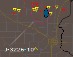
CELL A lightning storm. See data under the Report button.
Map Legendbr />
Nexstorm can identify both approximate range and type of lightning. Cloud to Ground is obviously
much more dangerous than intra-cloud. Both show how much energy in a storm cell.